
Why Does Bihar Face Floods Every Year? An Analytical Deep Dive (2025 Edition)
Introduction
Bihar experiences a yearly catastrophe when the monsoon rains arrive: floods. Crops are destroyed, infrastructure crumbles under strain, entire districts are swamped, and millions are relocated.
However, why does this occur nearly annually? Is it merely the wrath of nature, or are there more profound administrative, regional, and structural causes?
This blog examines the origins, effects, and potential remedies for Bihar’s flood issue using an Analytical Evidence-Oriented (AEO) methodology.
1. The Geography Factor – Rivers as a Double-Edged Sword
Major Rivers: Kosi, Gandak, Bagmati, Kamla, Mahananda, and Burhi Gandak are some of the Ganga’s principal tributaries. Bihar is located on the Ganga plains.
Millions of people in North Bihar are impacted by the Kosi River, sometimes known as the “Sorrow of Bihar,” which frequently changes its course and breaches.
Low-Lying Terrain: Because of the flat ground gradient, water cannot readily drain, leading to protracted waterlogging.
Data Point:Bihar has the highest rate of flooding in India, with over 68,800 sq km, or 76% of the state’s North Bihar territory, at risk.
2. Monsoon Patterns – Nature’s Role
Heavy Rainfall in Catchment Areas: Although Bihar experiences monsoon rains, Nepal, the source of the Himalayan rivers, poses a greater threat.
Large amounts of water are fed into rivers that flow downstream into Bihar by sudden cloudbursts and glacial melts.
Timing Issue: Flooding is unavoidable when the Ganga is already overflowing and tributaries add extra water.
Example: In 2020, Bihar received about 20% excess rainfall compared to normal, while Nepal’s Terai saw record-breaking downpours.
3. Infrastructure Weakness – Embankments & Dams
Built to regulate rivers, embankments frequently collapse during high floods as a result of inadequate maintenance.
Siltation Issue: Bihar’s rivers raise their riverbeds and lose their ability to carry water due to the massive amounts of silt they bring in from the Himalayas.
Absence of Storage: Bihar lacks enough reservoirs to store back excess water, in contrast to states like MP or Maharashtra that have substantial dams.
Data Point: Bihar has over 3,700 km of embankments, yet more than 40% of flood damages are due to breaches.
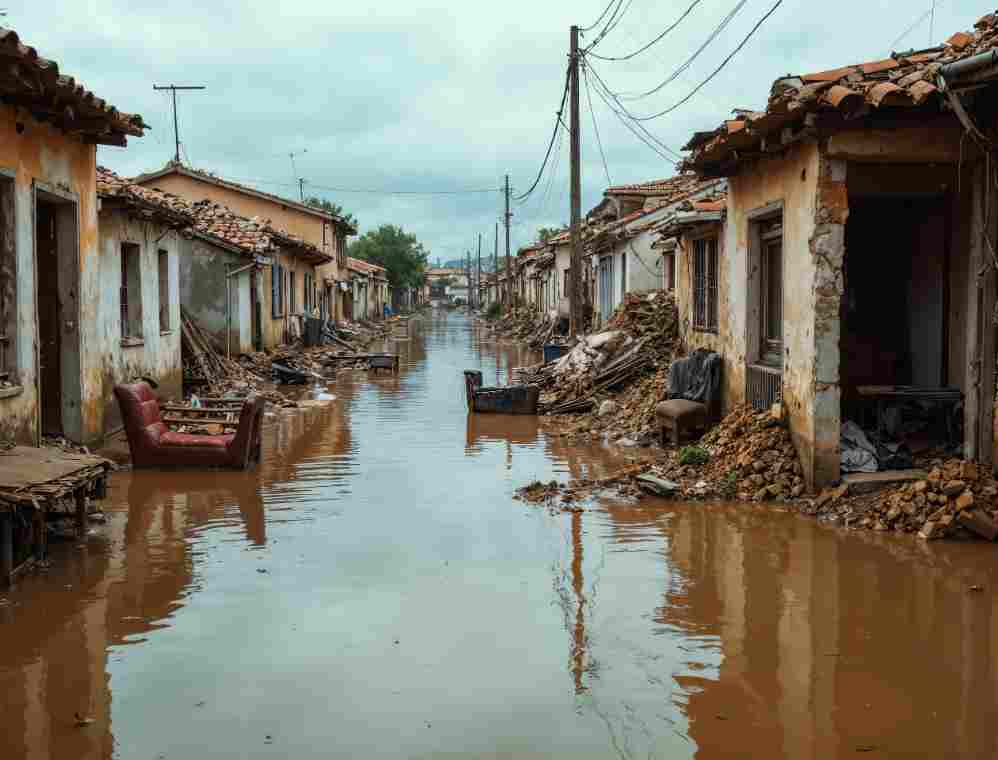
4. Human Factors – Why Floods Turn Disasters
Floodplain encroachment: The situation is made worse by the fast urbanization of natural drainage systems.
Deforestation in Catchment Areas: Runoff is accelerated in Nepal and North Bihar by a decrease in tree cover.
Inadequate Disaster Preparedness: Medical assistance, boats, and relief camps are frequently reactive rather than proactive.
Impact: In 2021, over 7 million people in 16 districts were affected by floods in Bihar, with thousands forced into temporary shelters.
5. Socio-Economic Impact – The Human Cost
Agriculture Loss: Bihar’s agrarian sector is severely impacted by floods that destroy vegetable, maize, and rice crops.
Migration: Seasonal migration to Delhi, Punjab, and Maharashtra for employment as a result of frequent floods.
Health Problems: Cholera, dengue, and other diseases are caused by waterlogging.
Disruption to Education: Schools frequently serve as makeshift shelters, which prevents kids from studying
6. Analytical Approach – Why Floods Persist Every Year
Evidence 1: Geography + Monsoon → Natural vulnerability.
Evidence 2: Infrastructure → Embankments & siltation make rivers unstable.
Evidence 3: Human actions → Encroachment + deforestation amplify risks.
Evidence 4: Governance gaps → Focus remains on relief, not prevention.
Conclusion from Analysis: Bihar floods are not just a “natural calamity.” They are a recurrent, predictable disaster, worsened by poor planning and weak infrastructure.
What Can Be Done? – Evidence-Oriented Solutions
1. Management of the River Basin (with Nepal): cooperative reservoirs and flood prediction systems.
2. Desiltation Projects: To keep rivers deep, regular dredging is required.
3. Embankment Overhaul: Install reinforced designs in place of old mud embankments.
4. Urban Planning: Establish water retention zones and prohibit building in floodplains.
5. Disaster Preparedness: Install early warning systems, construct permanent flood shelters, and keep emergency supplies on hand.
6. Long-Term Strategy: Use technology and community involvement to transition from “Flood Control” to “Flood Management.”
Global Example: Netherlands uses “Room for the River” projects, allowing controlled flooding in designated areas while protecting cities. Bihar could adapt similar models.
Conclusion
Bihar’s floods are a yearly tragedy but not an unsolvable one.
An Analytical Evidence-Oriented (AEO) approach shows that the floods are a mix of:
Natural geography,
Monsoon intensity,
Infrastructure weaknesses, and
Human mismanagement.
The key lies in long-term planning, scientific solutions, and regional cooperation.
Until then, millions in Bihar will continue to live with the haunting question every monsoon:
“When will the next flood wash everything away again?”
Disclaimer
The information and content shared on digitalgithub.com — including articles, blogs, news, guides, and other resources — is intended for general informational and educational purposes only. We do not guarantee the completeness, reliability, or suitability of any information. Always seek the guidance of a qualified professional before making decisions based on the information you read. Use this site at your own risk.